Weather for Cancun and Quintana Roo June 30, 2021
Share

They predict a new tropical wave that will approach the states of the Yucatan Peninsula.
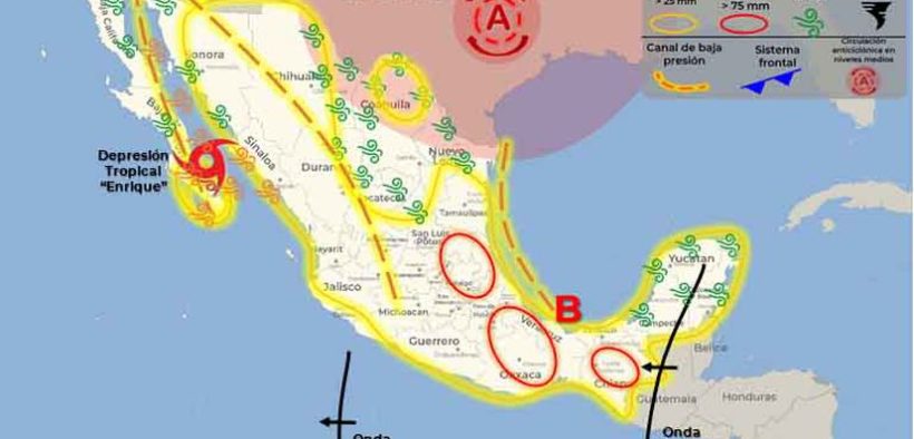
Tropical Storm “Enrique” is located off the coasts of Sinaloa and Nayarit, maintains its slow movement towards Baja California Sur and gradually weakens. Its wide circulation, in combination with divergence in height, will cause heavy to very strong rains accompanied by electrical activity in the northwest and west of Mexico, forecasting intense punctual storms in Baja California Sur (south), Sinaloa and Durango, which could generate landslides. , overflowing rivers and flooding in low parts of the land, reported the National Meteorological Service.
Likewise, strong gusts of wind and high waves are expected on the coasts of Baja California Sur, Sinaloa, Nayarit and Jalisco.
Likewise, tropical wave Number 6 will travel through the center and south of the national territory, it is combined with a low pressure channel that extends over the interior of the country and with the entry of humidity from the Pacific Ocean and the Gulf of Mexico, causing heavy rains to very strong accompanied by electrical discharges and possible hail fall on entities of the southeast, east, center and south of the Mexican Republic, including the Valley of Mexico and the Yucatan Peninsula, with intense punctual rains in Tamaulipas, Veracruz, Puebla, Oaxaca and Chiapas.
On the other hand, the frontal system No. 60 (out of season) extends with stationary characteristics and in the process of dissipation over northern Mexico, however, it will maintain the probability of heavy to very heavy showers and rains, electric shocks and possible hailstorms in the northwest, north and northeast of the country, with occasional heavy rains in Chihuahua.
Finally, a new tropical wave (possible No. 7) will approach the Yucatan Peninsula at the end of this day or the first hours of Wednesday.
They forecast very heavy rains with intense point rains (75.1 to 150.0 mm) in Baja California sur (south), Chihuahua, Durango, Sinaloa, Tamaulipas, Veracruz, Puebla, Oaxaca and Chiapas
Heavy rains with very strong point rains (50.1 to 75.0 mm): Sonora, Nayarit, Guerrero, San Luis Potosí, Hidalgo and Tabasco.
Intervals of showers with strong point rains (25.1 to 50.0 mm): Coahuila, Nuevo León, Zacatecas, Aguascalientes, Jalisco, Michoacán, Guanajuato, Querétaro, Tlaxcala, State of Mexico, Mexico City, Morelos, Campeche and Quintana Roo.
Intervals of showers (5.1 to 25.0 mm): Colima and Yucatán.
Isolated showers (0.1 to 5.0 mm): Baja California.
Possible hail fall: Baja California Sur, Sonora, Chihuahua, Coahuila, Nuevo León, Tamaulipas, Durango, Sinaloa, Guanajuato, Querétaro, Hidalgo, State of Mexico, Mexico City, Puebla, Jalisco, Michoacán, Guerrero, Oaxaca, Chiapas, Veracruz and Campeche.


